City of Concordia Continues to Pursue Adjustments to FEMA Flood Maps
National engineering firm Benesch is continuing to assemble data, prepare and submit an application for a Letter of Map Revision to the Federal Emergency Management Agency (FEMA) in an effort to remove structures from the floodplain and allow these property owners to no longer have to pay for flood insurance if they have a mortgage on the property.
On July 16, 2014, FEMA floodplain maps went into effect putting a number of citizens in the City of Concordia into the floodplain. The impact of this mapping was that a number of homeowners with federally backed mortgages were required to purchase and carry flood insurance on their homes and businesses, at a significant expense.
The city has done extensive work over the last decade to mitigate the potential for flooding of residents and businesses in Concordia.
In 2021, the city was able to secure technical assistance funding from the Kansas Department of Agriculture, Division of Water Resources (KDA-DWR) to restudy this area, which was completed in March 2022. The Kansas Department of Agriculture gathered current floodplain data using LiDAR, a remote sensing method, and Storm Water Management Modeling (SWMM), an open-source software application that can be used for single event or long-term simulations of water runoff quality and quantity, taking into consideration the 21st Street Dam and the city’s existing storm sewer system. The results of this project appeared favorable for Concordia homeowners and more accurate of actual flooding conditions, reducing the size of the floodplain. Therefore the city decided to move forward with a Letter of Map Revision process to change the floodplain map.
The city retained Benesch to provide services associated with the development and submission of a Letter of Map Revision request to FEMA. The expectation at the time was to use the data previously developed as part of the KDA-DWR technical assistance project and provided to the city, which included updated flood modeling and mapping developed by one of KDA-DWR’s on-call consultants, AECOM, for the Letter of Map Revision submittal. The scope of the FEMA Letter of Map Revision project included a review of the modeling and mapping for FEMA compliance, preparation of the documentation, datasets, and panels needed for a Letter of Map Revision submittal package, and assistance with public notice and outreach.
Upon review of the modeling and mapping data, Joe File, Professional Engineer, Certified Floodplain Manager with Benesch told the members of the Concordia City Commission on Wednesday, March 20th that they identified several errors and issues that needed to be resolved to achieve FEMA compliance and ultimately obtain Letter of Map Revision approval. Benesch coordinated with city staff and KDA-DWR staff to discuss these concerns. KDA-DWR staff were under the impression that the modeling and mapping would be suitable for Letter of Map Revision submittal and wanted to follow through with providing the city with high quality data.
Therefore, KDA-DWR, with support from FEMA, agreed to fund a second phase of the technical assistance project for the City of Concordia and utilized Benesch, another one of their on-call consultants, to develop a new rainfall-runoff model for the city that limits model instability, flow losses and addressed errors; thus being of the quality suitable for FEMA compliance. The project also included the development of draft floodplains that adequately represent the flood risk.
The modeling was also done in a software package that is more widely accepted in the industry and more useful to the community in the future.
The second KDA-DWR technical assistance project for Concordia concluded in February 2024.
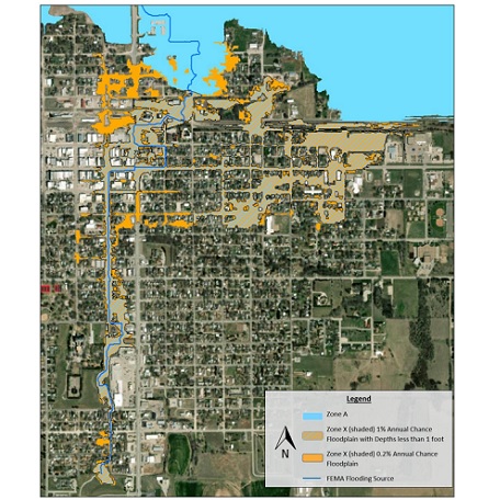
Draft floodplains were developed for the tributary to the Republican River to represent the one percent annual chance (100yr) and 0.2 percent annual chance (500yr) storm events. The majority of the flooding associated with the one percent annual chance draft floodplain for the subject stream is very shallow in nature, much of which is only a couple inches in depth. In addition, for much of this floodplain there is no channel with defined bed and banks.
Typically, FEMA defines a regulatory Zone A special flood hazard area as a hazard zone that corresponds to the one percent annual chance floodplains. However, in the case of shallow flooding areas, FEMA defines one percent annual chance flooding where average depths are less than 1.0 foot as a Zone X moderate flood hazard, which would only be considered an advisory floodplain. File reported the average one percent annual chance flood depths for the tributary to the Republican River are less than one foot and there is a lack of continuous channel through town.
Given these conditions, at Benesch’s recommendation, the city requested concurrence with FEMA Region 7, with support from the KDA DWR, to change the Zone A special flood hazard area for the tributary to the Republican River to a Zone X flood hazard with average depths less than one foot. FEMA Region 7 concurrence has already been obtained for this zone change.
The Zone X designation would result in advisory floodplains that do not have mandatory flood insurance purchase requirements for homeowners with federally backed mortgages and have minimal regulatory requirements which are generally only tied to critical infrastructure.
Benesch is moving forward with the FEMA Letter of Map Revision project at this time per its original agreement with the city. The Letter of Map Revision package will be prepared and is proposed to be submitted to FEMA in April for review.
Upon acceptance of the Letter of Map Revision by the FEMA reviewers, public notifications will be sent to Concordia residents and a public meeting will be scheduled.
File said they estimate official FEMA approval will likely be achieved within approximately six months of initial submittal, or sometime in the fall of 2024.
Also during this week's Concordia City Commission meeting, the commission voted to accept a bid from BHS Construction in the amount of $104,317.95 to construct a paved extension of 20th Street with curb and gutter to support a new pull-through car wash planned for 1909 Lincoln Street. The location was previously home to Thunder Strikez Bowling Alley, which was destroyed in a large fire in September 2020.
BHS Construction is constructing CJ's Car Wash.
Christi and Jason Gordon of Parker, Colorado are the developers of CJ's Car Wash. Currently, there are no express tunnel car washes in Concordia that offer the convenience of being able to stay inside your car while your car gets washed in two minutes. The car wash officially broke ground last week. Business operations are targeted to start in September 2024.
The city, at its expense, has agreed to provide and construct a paved extension of 20th Street with curb and gutter to a point just beyond the proposed site entry, comprising an estimated 173 square yards of reinforced concrete pavement and associated work, including design and inspection.
The commission also authorized City Manager Amy Lange to sign a license agreement for private storage in a public right-of-way, allowing BHS Construction to proceed with construction of CJ's Car Wash in an efficient manner. BHS Construction requested the city's permission to use the undeveloped 20th Street right-of-way and the eastern portion of the alley between the construction site and the developed property to the north owned by the city for temporary private storage of construction materials and equipment.
The license agreement will expire September 30, 2024.
The commission also authorized City Manager Lange to apply for a City Connecting Link Improvement Program (CCLIP) pavement restoration grant of $1.5 million to fund repairs needed on the north and south end of the viaduct on US Highway 81, as well as other spots in need of work. If accepted, funding for the project will be 90 percent funded by the Kansas Department of Transportation and 10 percent will be funded by the city.
And the commission approved the purchase of eleven Taser 10 from AXON Technologies for the Concordia Police Department in the amount of $54,625.00, to be paid out of the police department's equipment reserve fund over the next five years. Concordia Police Chief Brent Gering noted that in the past year the Concordia Police Department has adopted body-worn cameras from AXON, which are compatible with the new Taser 10 devices.